


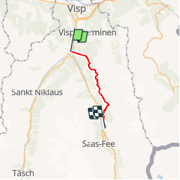
J6 Chemib d'altitude Gsponer Höhenweg

vassaux
User

Length
17.2 km

Max alt
2281 m

Uphill gradient
1727 m
Km-Effort
38 km

Min alt
753 m

Downhill gradient
951 m
Boucle
No
Creation date :
2014-12-10 00:00:00.0
Updated on :
2014-12-10 00:00:00.0
8h06
Difficulty : Unknown

FREE GPS app for hiking
 SityTrail
IGN / Geographical institutes
SityTrail Plus
The world is yours!
About
Trail Walking of 17.2 km to be discovered at Valais/Wallis, Visp, Stalden (VS). This trail is proposed by vassaux.
Positioning
Country:
Switzerland
Region :
Valais/Wallis
Department/Province :
Visp
Municipality :
Stalden (VS)
Location:
Unknown
Start:(Dec)
Start:(UTM)
412938 ; 5120419 (32T) N.
Comments
